Gwynedd Archaeological
Trust Regional Historic Environment Record
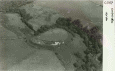
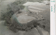
Craig y Dinas Hillfort, Pontllyfni
Primary Reference Number (PRN) : 1312 Trust : Gwynedd Community : Llanllyfni Unitary authority : Gwynedd NGR : SH448520 Site Type (preferred type first) : UNKNOWN HILLFORT Status : Scheduled Monument
Description : A hillfort occupying the flat top of a promontory, the edge of which is protected by a badly ruined wall at least 3.3m thick externally faced with slabs, the outer face nowhere survives more than 0.3m to 0.6m high, and the inner is visible. The neck of the promontory is crossed by two strong ramparts and ditches, with a counterscarp bank. About 2m outside the outer face of this wall is a second facing of rounded boulders, now standing 2or 3 courses high, the space between this and the first wall is filled with rubble. There were two entrances one at each end of the inner rampart across the neck, they appear to have been simple passages 4m wide. They are approached along the edge of the promontory past the ends of the outer rampart. It would appear that the fortress incorporates work of two periods.
Three spindle whorls have been found in the interior, which has been ploughed. It contains a large ill defined mound which may be artificial. <1>
Not visited. (Smith, 2005)
“It is a large Encampment, towards the land side protected by two very lofty ramparts, the inner of Stone and outer of Earth, with a wide and deep foss between. These ramparts extend for near two thirds of its compass, the other part being naturally precipitous, not requiring much defence above the river very steep. In the centre a rising like an old Carnedd. In several places, at no great distance from it, more of the Cyttiau [Gwyddelod].” (Fenton, 1813).
Description of Craig-y-Dinas hillfort (Williams, 1871).
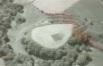
On the 2021 Survey and Excavations: Most of the geophysical survey anomalies were interpreted as being archaeological features with a low degree of certainty. On excavation, all apart from feature 1 were found to be a result of variations in the underlying glacial deposits that contains bands and patches of sand, silt, gravel and large stones. The low linear bank (A003) corresponded almost exactly to the geophysical anomaly although there was little evidence of the feature in the excavation apart from a slight increase in the depth of topsoil. Interpretation of such an ephemeral feature is problematic but it is most likely to be a relatively recent bank or raised trackway running from the entranced although an earlier ploughed out feature cannot be entirely ruled out. The five trenches sampled a very small proportion of the interior of the fort (1.75%) although they were positioned in areas where activity would be expected to be found in an Iron Age promontory fort, namely around the inside of the rampart and on the raised mound. There was little to indicate any kind of activity. There were no in situ heat affected areas, no cut features, no finds and no visible residual charcoal in the topsoil. This suggests that there may not have been dense sustained occupation in the Iron Age or Romano British period.
The most significant findings of the excavation may be indications that the interior of the promontory fort has been cleared of most archaeological features. Little evidence for occupation and activities in any period were discovered in the rather limited areas of excavation. A wider area of excavation could uncover further evidence. Given the limited depth of stratigraphy further geophysical survey in the form of GPR or resistivity would probably be unproductive (Hopewell. 2022).
Events : 41849 : Prn 1312 25 Inch Survey (year : 1972) 40621 : Prehistoric Defended Enclosures in North-west Wales, 2004-5: West Conwy, Gwynedd (Arfon) and Anglesey (year : 2005) 44557 : Early Celtic Societies in North Wales (year : 2010) 45042 : Iron Age Settlements in Wales: Cadw Defended Enclosures Publication. Hillforts and Hut Groups in North-West Wales. (year : 2008) 40620 : Prehistoric Defended Enclosures: Scoping for Pan-Wales Assessment (year : 2003) 46241 : Excavation and Survey at Craig y Dinas: Geophysical Survey and Community Excavation (year : 2022)